Geolocate

Aleppo topographic map

Click on the map to display elevation.

About this map
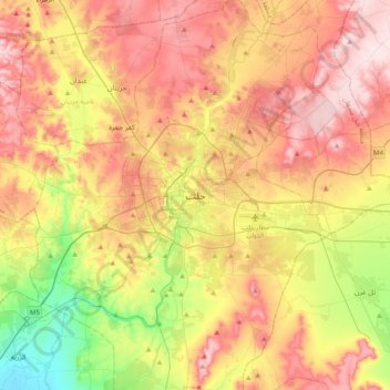
Name: Aleppo topographic map, elevation, terrain.

Location: Aleppo, Mount Simeon Subdistrict, Mount Simeon District, Aleppo Governorate, Syria (36.03924 37.00373 36.35924 37.32373)

Average elevation: 1,355 ft

Minimum elevation: 860 ft

Maximum elevation: 1,818 ft

Other topographic maps

Click on a map to view its topography, its elevation and its terrain.

Al-Khafsa Subdistrict

Syria > Aleppo Governorate

Average elevation: 1,217 ft

Al-Khafsa Subdistrict

Syria > Aleppo Governorate

Average elevation: 1,217 ft

Lake Jabbūl

Syria > Aleppo Governorate

Average elevation: 1,168 ft

Citadel of Aleppo

Syria > Aleppo Governorate > Aleppo

Average elevation: 1,289 ft

Queiq

Syria > Aleppo Governorate

Average elevation: 1,362 ft

سبخة المطخ

Syria > Aleppo Governorate

Average elevation: 804 ft

Al-Hader Subdistrict

Syria > Aleppo Governorate

Average elevation: 906 ft

Derbazîn Horî

Syria > Aleppo Governorate

Average elevation: 1,312 ft

Tash

Syria > Aleppo Governorate

Average elevation: 1,575 ft

Jindires Subdistrict

Syria > Aleppo Governorate

Average elevation: 1,037 ft

Mount Simeon Subdistrict

Syria > Aleppo Governorate

Average elevation: 1,345 ft

Gear up for your next adventure:

🧥Men's Rain Shells - Premium waterproof and breathable jackets for mountain weather
🌧️Backpack Rain Cover - Keep gear dry in wet weather
🦶Carbon Trekking Poles - Reduce knee impact on steep descents with ultra-light poles
🧭Hiking Compass - Precision compass for reliable navigation in the wilderness
🗃️Trail First Aid Kit - Essential kit for outdoor injuries and emergencies

As an Amazon Associate, this site earns from qualifying purchases at no extra cost to you.