
Make a donation
Gear up for your next adventure:
As an Amazon Associate, this site earns from qualifying purchases at no extra cost to you.
Tarbot topographic map
Click on the map to display elevation.
Make a donation
Gear up for your next adventure:
As an Amazon Associate, this site earns from qualifying purchases at no extra cost to you.
About this map
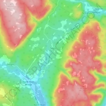
Name: Tarbot topographic map, elevation, terrain.
Average elevation: 561 ft
Minimum elevation: -3 ft
Maximum elevation: 1,237 ft
Make a donation
Gear up for your next adventure:
As an Amazon Associate, this site earns from qualifying purchases at no extra cost to you.
Other topographic maps
Click on a map to view its topography, its elevation and its terrain.
South Harbour
Canada > Nova Scotia > Municipality of Victoria County > South Harbour
Average elevation: 72 ft
Kidston Island Lighthouse
Canada > Nova Scotia > Municipality of Victoria County > Baddeck
Average elevation: 36 ft
Old Fort Point
Canada > Nova Scotia > Municipality of Victoria County > Englishtown
Average elevation: 105 ft