Geolocate

Gefrees topographic map

Click on the map to display elevation.

About this map

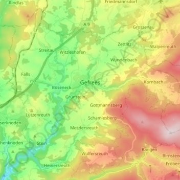
Name: Gefrees topographic map, elevation, terrain.

Location: Gefrees, Landkreis Bayreuth, Bavaria, 95482, Germany (50.04970 11.67457 50.13393 11.81840)

Average elevation: 1,919 ft

Minimum elevation: 1,260 ft

Maximum elevation: 2,792 ft

Other topographic maps

Click on a map to view its topography, its elevation and its terrain.

Weidensees

Germany > Bavaria > Landkreis Bayreuth > Betzenstein

Average elevation: 1,539 ft

Trockau

Germany > Bavaria > Landkreis Bayreuth > Pegnitz

Average elevation: 1,644 ft

Bindlacher Berg

Germany > Bavaria > Landkreis Bayreuth > Bindlach

Average elevation: 1,398 ft

Gear up for your next adventure:

🧣Merino Neck Gaiters - Multi-functional headwear for wind and sun protection
🪶Multi‑Purpose Knife - Useful blade for camp and trail
🔪Outdoor Multitools - Essential survival tools for gear repair and field use
🧭Outdoor Navigation Book - Learn advanced navigation skills
🏕️Tent Footprint - Protect your tent base from wear

As an Amazon Associate, this site earns from qualifying purchases at no extra cost to you.