Geolocate

Norwich topographic map

Click on the map to display elevation.

About this map

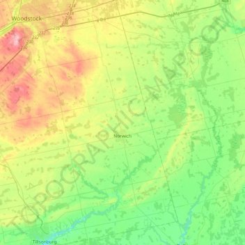
Name: Norwich topographic map, elevation, terrain.

Location: Norwich, Oxford County, Ontario, Canada (42.85514 -80.75371 43.15163 -80.50539)

Average elevation: 879 ft

Minimum elevation: 676 ft

Maximum elevation: 1,270 ft

Other topographic maps

Click on a map to view its topography, its elevation and its terrain.

Tavistock

Canada > Ontario > Oxford County

Average elevation: 1,145 ft

Gear up for your next adventure:

🪶Wildlife Field Guides - Learn animal tracking and species ID
🎒Day Hiking Backpack - Lightweight backpack perfect for day trips and outdoor adventures
🛠️Backpacking Tool Kit - Essential toolkit for outdoor repairs
🔭Compact Binoculars - HD vision for scouting terrain and identifying distant landmarks
📡GPS Antenna Upgrade - Enhance GPS reception in remote terrain

As an Amazon Associate, this site earns from qualifying purchases at no extra cost to you.