
Make a donation
Gear up for your next adventure:
As an Amazon Associate, this site earns from qualifying purchases at no extra cost to you.
Capulin Volcano National Monument topographic map
Click on the map to display elevation.
Make a donation
Gear up for your next adventure:
As an Amazon Associate, this site earns from qualifying purchases at no extra cost to you.
Capulin Volcano National Monument
Capulin Volcano National Monument is a well-preserved, relatively young (55,000 to 62,000 years old), symmetrical cinder cone. It rises steeply from the surrounding grassland plains to an elevation of 8,182 feet above sea level. The irregular rim of the crater is about a mile in circumference and the crater about 400 feet deep.
Make a donation
Gear up for your next adventure:
As an Amazon Associate, this site earns from qualifying purchases at no extra cost to you.
About this map
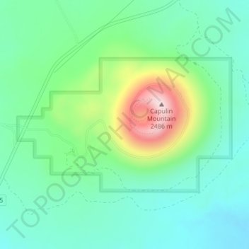
Name: Capulin Volcano National Monument topographic map, elevation, terrain.
Average elevation: 7,201 ft
Minimum elevation: 6,841 ft
Maximum elevation: 8,143 ft
Union County trails, hiking, mountain biking, running and outdoor activities
Make a donation
Gear up for your next adventure:
As an Amazon Associate, this site earns from qualifying purchases at no extra cost to you.