
Rittershof topographic map
Click on the map to display elevation.
Rittershof
Altenhof | Auhof | Autobahnmeisterei Neumarkt i.d.OPf. | Beckenmühle | Blomenhof | Bodenhof | Bodenmühle | Eichenmühle | Frickenhofen | Friedlmühle | Fuchsberg | Großwiesenhof | Guglhof | Habersmühle | Helena | Höhenberg | Höhenberg im Tal | Holzheim | Iberlsmühle | Ischhofen | Karhof | Kohlenbrunnermühle | Koppenmühle | Labersricht | Lähr | Lampertshofen | Lippertshofen | Neumarkt in der Oberpfalz | Ottosau | Pelchenhofen | Pölling | Rittershof | Rödelberg | Schafhof | Schleifmühle | Schmermühle | Schönmühle | Stauf | Steinberg | Tiefenbrunn | Ungenricht | Voggenthal | Woffenbach | Wolfstein | Wolfstein
About this map
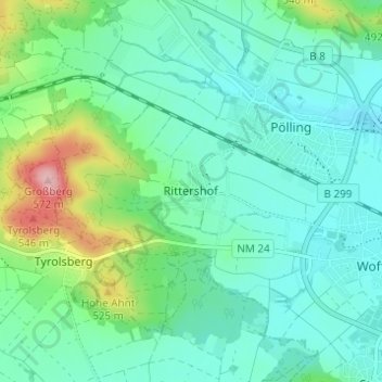
Name: Rittershof topographic map, elevation, terrain.
Average elevation: 1,493 ft
Minimum elevation: 1,378 ft
Maximum elevation: 1,877 ft
Other topographic maps
Click on a map to view its topography, its elevation and its terrain.
92318
Deutschland > Bayern > Landkreis Neumarkt in der Oberpfalz > Neumarkt in der Oberpfalz > Höhenberg im Tal
Average elevation: 1,683 ft