
Eugenio Espejo topographic map
Interactive map
Click on the map to display elevation.
About this map
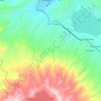
Name: Eugenio Espejo topographic map, elevation, terrain.
Location: Eugenio Espejo, Otavalo, Imbabura, Ecuador (0.13759 -78.27185 0.22967 -78.22599)
Average elevation: 10,095 ft
Minimum elevation: 8,330 ft
Maximum elevation: 13,366 ft
Other topographic maps
Click on a map to view its topography, its elevation and its terrain.
Pucará Alto
Pucará Alto, Eugenio Espejo, Otavalo, Imbabura, 100403, Ecuador
Average elevation: 8,783 ft
Lago San Pablo
Ecuador > Imbabura > Otavalo > Calpaquí
Lago San Pablo, Calpaquí, Eugenio Espejo, Otavalo, Imbabura, Ecuador
Average elevation: 8,776 ft
San Juan de Ilumán
Ecuador > Imbabura > Otavalo > San Juan de Ilumán
San Juan de Ilumán, Otavalo, Imbabura, Ecuador
Average elevation: 8,753 ft
Selva Alegre
Selva Alegre, Otavalo, Imbabura, Ecuador
Average elevation: 5,994 ft
San Pablo del Lago
San Pablo del Lago, Otavalo, Imbabura, 100210, Ecuador
Average elevation: 10,056 ft