
Make a donation
Gear up for your next adventure:
As an Amazon Associate, this site earns from qualifying purchases at no extra cost to you.
Pellworm topographic map
Click on the map to display elevation.
Make a donation
Gear up for your next adventure:
As an Amazon Associate, this site earns from qualifying purchases at no extra cost to you.
Pellworm
Auch heute kann es auf Pellworm unter Zusammentreffen aller ungünstigen Voraussetzungen zu einer den Deich überspülenden Sturmflut kommen. Die Fluten von 1831, 1911, 1936, 1962, 1976 und 1981 konnten die Insel nur deshalb nicht gefährden, da der Deich immer wieder erhöht wurde. Die drei letztgenannten Sturmfluten waren höher als die Flut von 1825. Aber auch der immer tiefer und breiter werdende Heverstrom und seine Seitenarme gefährden die Insel. Man konnte noch vor einigen Jahren die Norderhever zwischen Pellworm und Nordstrand bei Niedrigwasser durchwaten. Heute ist die Norderhever dort sechs bis neun Meter tief.
Make a donation
Gear up for your next adventure:
As an Amazon Associate, this site earns from qualifying purchases at no extra cost to you.
About this map
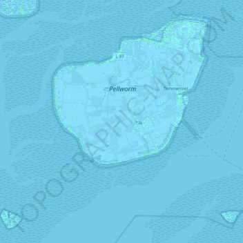
Name: Pellworm topographic map, elevation, terrain.
Average elevation: 0 ft
Minimum elevation: -13 ft
Maximum elevation: 20 ft
Make a donation
Gear up for your next adventure:
As an Amazon Associate, this site earns from qualifying purchases at no extra cost to you.
Other topographic maps
Click on a map to view its topography, its elevation and its terrain.
Make a donation
Gear up for your next adventure:
As an Amazon Associate, this site earns from qualifying purchases at no extra cost to you.
Bundesgaard
Deutschland > Schleswig-Holstein > Kreis Nordfriesland > Neukirchen
Average elevation: -3 ft
Archsum
Deutschland > Schleswig-Holstein > Kreis Nordfriesland > Sylt
Landwirtschaft und Seefahrt bildeten sehr lange die Lebensgrundlage der Archsumer Bewohner. 1611 wurden 38 Hofstellen gezählt, etwa 150 Menschen lebten im Dorf. 1709 gab es 42 Höfe und acht selbstständige Katen. 25 Männer und 53 Familien fuhren zu dieser Zeit als Seeleute auf der Nordsee. Die Abhängigkeit…
Average elevation: 3 ft
Make a donation
Gear up for your next adventure:
As an Amazon Associate, this site earns from qualifying purchases at no extra cost to you.
Nordermitteldeich
Deutschland > Schleswig-Holstein > Kreis Nordfriesland > Pellworm
Average elevation: -3 ft
Make a donation
Gear up for your next adventure:
As an Amazon Associate, this site earns from qualifying purchases at no extra cost to you.
Make a donation
Gear up for your next adventure:
As an Amazon Associate, this site earns from qualifying purchases at no extra cost to you.
Eiderstedt
Deutschland > Schleswig-Holstein > Kreis Nordfriesland > Poppenbüll
Average elevation: 0 ft
Bollhaus
Deutschland > Schleswig-Holstein > Kreis Nordfriesland > Süder-Waygaard
Average elevation: -7 ft
Bohmstedtfeld
Deutschland > Schleswig-Holstein > Kreis Nordfriesland > Bohmstedt
Average elevation: 30 ft
Ellenbogen
Deutschland > Schleswig-Holstein > Kreis Nordfriesland > List auf Sylt
Average elevation: 3 ft
Make a donation
Gear up for your next adventure:
As an Amazon Associate, this site earns from qualifying purchases at no extra cost to you.
Norderoog
Deutschland > Schleswig-Holstein > Kreis Nordfriesland > Hallig Hooge
Average elevation: 0 ft
Archsum
Deutschland > Schleswig-Holstein > Kreis Nordfriesland > Sylt
Landwirtschaft und Seefahrt bildeten sehr lange die Lebensgrundlage der Archsumer Bewohner. 1611 wurden 38 Hofstellen gezählt, etwa 150 Menschen lebten im Dorf. 1709 gab es 42 Höfe und acht selbstständige Katen. 25 Männer und 53 Familien fuhren zu dieser Zeit als Seeleute auf der Nordsee. Die Abhängigkeit…
Average elevation: 3 ft
Make a donation
Gear up for your next adventure:
As an Amazon Associate, this site earns from qualifying purchases at no extra cost to you.