
Corsept topographic map
Click on the map to display elevation.
About this map
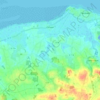
Name: Corsept topographic map, elevation, terrain.
Average elevation: 33 ft
Minimum elevation: -66 ft
Maximum elevation: 138 ft
Other topographic maps
Click on a map to view its topography, its elevation and its terrain.
La Vieille-Ville
France > Pays de la Loire > Loire-Atlantique > La Chapelle-Glain
Average elevation: 236 ft
La Grande Ragotière
France > Pays de la Loire > Loire-Atlantique > La Regrippière
Average elevation: 262 ft
Réserve naturelle de la Pointe Saint-Gildas
France > Pays de la Loire > Loire-Atlantique > Préfailles
Average elevation: 7 ft
Le Port Cormier
France > Pays de la Loire > Loire-Atlantique > Nort-sur-Erdre > Le Port Cormier
Average elevation: 43 ft
Le Bout des Ponts
France > Pays de la Loire > Loire-Atlantique > Guémené-Penfao
Average elevation: 98 ft