Geolocate

Ubrug topographic map

Click on the map to display elevation.

About this map

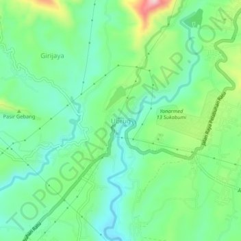
Name: Ubrug topographic map, elevation, terrain.

Location: Ubrug, Sukabumi, West Java, Java, 43115, Indonesia (-6.96777 106.73591 -6.92777 106.77591)

Average elevation: 1,014 ft

Minimum elevation: 761 ft

Maximum elevation: 1,598 ft

Other topographic maps

Click on a map to view its topography, its elevation and its terrain.

Cibodas

Indonesia > West Java > Sukabumi > Cimenteng

Average elevation: 853 ft

Cisolok

Indonesia > West Java > Sukabumi

Average elevation: 203 ft

Cikahuripan

Indonesia > West Java > Sukabumi

Average elevation: 361 ft

Gear up for your next adventure:

🦟Ultrasonic Repellers - Create a bug-free zone at your camp or rest stop
🥤Water Filter Bottle - All‑in‑one filter bottle for safe hydration
🛡️Insect Repellent - Protection against bugs during outdoor activities
🪶Paracord Bracelet - Survival bracelet with built‑in tools
🎁Geography Themed Gifts - Unique gift ideas for map lovers and geography enthusiasts

As an Amazon Associate, this site earns from qualifying purchases at no extra cost to you.