
Thank you for supporting this site ❤️
Make a donation
Make a donation
Gear up for your next adventure:
As an Amazon Associate, this site earns from qualifying purchases at no extra cost to you.
Gulpilhares topographic map
Click on the map to display elevation.
Thank you for supporting this site ❤️
Make a donation
Make a donation
Gear up for your next adventure:
As an Amazon Associate, this site earns from qualifying purchases at no extra cost to you.
About this map
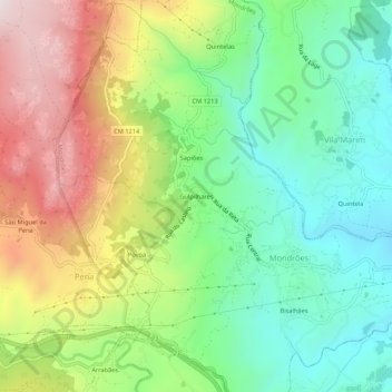
Name: Gulpilhares topographic map, elevation, terrain.
Location: Gulpilhares, Mondrões, Vila Real, 5000-319, Portugal (41.27903 -7.82056 41.31903 -7.78056)
Average elevation: 2,133 ft
Minimum elevation: 1,191 ft
Maximum elevation: 3,609 ft
Thank you for supporting this site ❤️
Make a donation
Make a donation
Gear up for your next adventure:
As an Amazon Associate, this site earns from qualifying purchases at no extra cost to you.