Geolocate

Middle Mead topographic map

Click on the map to display elevation.

About this map

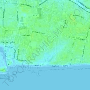
Name: Middle Mead topographic map, elevation, terrain.

Location: Middle Mead, Littlehampton, Arun, West Sussex, England, United Kingdom (50.80796 -0.52540 50.80939 -0.52349)

Average elevation: 13 ft

Minimum elevation: -7 ft

Maximum elevation: 30 ft

Other topographic maps

Click on a map to view its topography, its elevation and its terrain.

Wick

United Kingdom > England > West Sussex > Arun > Littlehampton > Lyminster

Average elevation: 10 ft

Gear up for your next adventure:

🥇GPS Hiking Watch - Multi‑sport GPS watch with navigation and trail tracking
🧴Hand Sanitizer - Keep hands clean while hiking
🧯Portable Fire Pit - Compact fire pit for camping spots
🚑Emergency Bivvies - Heat-reflective sleeping bags for survival situations
🗻Climbing Gear Basics - Essential gear for beginner climbers

As an Amazon Associate, this site earns from qualifying purchases at no extra cost to you.