
Friesoythe topographic map
Interactive map
Click on the map to display elevation.
About this map
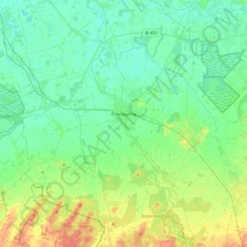
Name: Friesoythe topographic map, elevation, terrain.
Location: Friesoythe, Cloppenburg district, Lower Saxony, 26169, Germany (52.90434 7.70359 53.11977 7.96121)
Average elevation: 43 ft
Minimum elevation: 3 ft
Maximum elevation: 148 ft
Other topographic maps
Click on a map to view its topography, its elevation and its terrain.
Saterland - Seelterlound
Germany > Lower Saxony > Cloppenburg district
Saterland - Seelterlound, Cloppenburg district, Lower Saxony, 26683, Germany
Average elevation: 16 ft
Saterland - Seelterlound
Germany > Lower Saxony > Cloppenburg district > Saterland - Seelterlound > Saterland - Seelterlound
Saterland - Seelterlound, Cloppenburg district, Lower Saxony, 26683, Germany
Average elevation: 20 ft