Geolocate

Bass topographic map

Click on the map to display elevation.

About this map

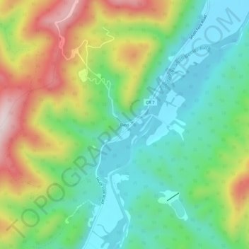
Name: Bass topographic map, elevation, terrain.

Location: Bass, Hardy County, West Virginia, United States (38.92844 -79.02225 38.96844 -78.98225)

Average elevation: 1,450 ft

Minimum elevation: 909 ft

Maximum elevation: 2,434 ft

Hardy County trails, hiking, mountain biking, running and outdoor activities

Other topographic maps

Click on a map to view its topography, its elevation and its terrain.

Lost River

United States > West Virginia > Hardy County

Average elevation: 1,522 ft

Gear up for your next adventure:

🥾Women's Hiking Boots - Top-rated trail boots with ankle support and superior grip
🧭Orienteering Set - Complete compass and map reading kit
Backpacking Tents - Weight-optimized shelters for multi-day topographic surveys
🌎3D Topographic Globes - Raised relief globes for a tactile understanding of geography
🪶Compact Camp Shovel - Folding shovel for campsite tasks

As an Amazon Associate, this site earns from qualifying purchases at no extra cost to you.