
Tanganyika topographic map
Interactive map
Click on the map to display elevation.
About this map
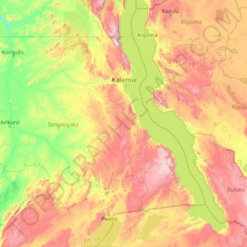
Name: Tanganyika topographic map, elevation, terrain.
Location: Tanganyika, DR Congo (-8.39556 25.94147 -4.99995 30.79275)
Average elevation: 3,383 ft
Minimum elevation: 1,588 ft
Maximum elevation: 8,550 ft
Other topographic maps
Click on a map to view its topography, its elevation and its terrain.