
Make a donation
Gear up for your next adventure:
As an Amazon Associate, this site earns from qualifying purchases at no extra cost to you.
Down Ampney topographic map
Click on the map to display elevation.
Make a donation
Gear up for your next adventure:
As an Amazon Associate, this site earns from qualifying purchases at no extra cost to you.
About this map
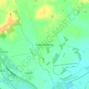
Name: Down Ampney topographic map, elevation, terrain.
Average elevation: 279 ft
Minimum elevation: 249 ft
Maximum elevation: 338 ft
Make a donation
Gear up for your next adventure:
As an Amazon Associate, this site earns from qualifying purchases at no extra cost to you.
Other topographic maps
Click on a map to view its topography, its elevation and its terrain.
Moreton-in-Marsh
United Kingdom > England > Gloucestershire > Cotswold District
Average elevation: 443 ft
Clearwater
United Kingdom > England > Gloucestershire > Cotswold District > Somerford Keynes
Average elevation: 289 ft
Aston Subedge
United Kingdom > England > Gloucestershire > Cotswold District > Weston-sub-Edge
Average elevation: 331 ft
Make a donation
Gear up for your next adventure:
As an Amazon Associate, this site earns from qualifying purchases at no extra cost to you.
Cold Aston
United Kingdom > England > Gloucestershire > Cotswold District > Cold Aston
Average elevation: 620 ft
Coberley
United Kingdom > England > Gloucestershire > Cotswold District > Coberley
Average elevation: 768 ft
Fairford
United Kingdom > England > Gloucestershire > Cotswold District > Fairford
Average elevation: 322 ft