
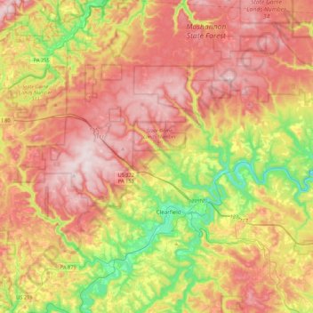
Lawrence Township topographic map
Interactive map
Click on the map to display elevation.
About this map
Name: Lawrence Township topographic map, elevation, terrain.
Average elevation: 1,719 ft
Minimum elevation: 984 ft
Maximum elevation: 2,388 ft
Clearfield County trails, hiking, mountain biking, running and outdoor activities
Other topographic maps
Click on a map to view its topography, its elevation and its terrain.
Pottersdale
United States > Pennsylvania > Clearfield County > Karthaus Township
Average elevation: 1,293 ft
Frenchville
United States > Pennsylvania > Clearfield County > Covington Township
Average elevation: 1,437 ft
Kylertown
United States > Pennsylvania > Clearfield County > Cooper Township
Average elevation: 1,591 ft
Mount Hope
United States > Pennsylvania > Clearfield County > Lawrence Township
Average elevation: 1,375 ft
Sylvis
United States > Pennsylvania > Clearfield County > Burnside Township
Average elevation: 1,650 ft
Utahville
United States > Pennsylvania > Clearfield County > Beccaria Township > Utahville
Average elevation: 1,650 ft