
Olive Hill topographic map
Interactive map
Click on the map to display elevation.
About this map
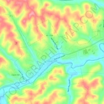
Name: Olive Hill topographic map, elevation, terrain.
Location: Olive Hill, Carter County, Kentucky, 41164, United States (38.29158 -83.19103 38.31492 -83.14352)
Average elevation: 899 ft
Minimum elevation: 741 ft
Maximum elevation: 1,076 ft
Other topographic maps
Click on a map to view its topography, its elevation and its terrain.
Wolf
United States > Kentucky > Carter County
Wolf, Carter County, Kentucky, United States
Average elevation: 889 ft
Grayson
United States > Kentucky > Carter County
Grayson, Carter County, Kentucky, United States
Average elevation: 682 ft
Denton
United States > Kentucky > Carter County
Denton, Carter County, Kentucky, 41132, United States
Average elevation: 761 ft
Hitchins
United States > Kentucky > Carter County
Hitchins, Carter County, Kentucky, 41146, United States
Average elevation: 705 ft
Grahn
United States > Kentucky > Carter County
Grahn, Carter County, Kentucky, 41142, United States
Average elevation: 873 ft