
Lewiston topographic map
Click on the map to display elevation.
About this map
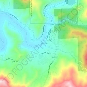
Name: Lewiston topographic map, elevation, terrain.
Location: Lewiston, Trinity County, California, 96052, United States (40.68737 -122.82752 40.72737 -122.78752)
Average elevation: 2,192 ft
Minimum elevation: 1,762 ft
Maximum elevation: 3,205 ft
Trinity County trails, hiking, mountain biking, running and outdoor activities
Other topographic maps
Click on a map to view its topography, its elevation and its terrain.
Whiskeytown-Shasta-Trinity National Recreation Area - Trinity Unit
United States > California > Trinity County
Average elevation: 3,770 ft