
Make a donation
Gear up for your next adventure:
As an Amazon Associate, this site earns from qualifying purchases at no extra cost to you.
Sverdlovsk Oblast topographic map
Click on the map to display elevation.
Make a donation
Gear up for your next adventure:
As an Amazon Associate, this site earns from qualifying purchases at no extra cost to you.
Sverdlovsk Oblast
The highest mountains all rise in the North Urals, Konzhakovsky Kamen at 1,569 metres (5,148 ft) and Denezhkin Kamen at 1,492 metres (4,895 ft). The Middle Urals is mostly hilly country with no discernible peaks; the mean elevation is closer to 300 to 500 metres (980 to 1,640 ft) above sea level. Principal rivers include the Tavda, the Tura, the Chusovaya, and the Ufa, the latter two being tributaries of the Kama.
Make a donation
Gear up for your next adventure:
As an Amazon Associate, this site earns from qualifying purchases at no extra cost to you.
About this map
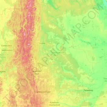
Name: Sverdlovsk Oblast topographic map, elevation, terrain.
Location: Sverdlovsk Oblast, Ural Federal District, Russia (56.05322 57.22655 61.94662 66.18486)
Average elevation: 571 ft
Minimum elevation: 43 ft
Maximum elevation: 4,764 ft
Make a donation
Gear up for your next adventure:
As an Amazon Associate, this site earns from qualifying purchases at no extra cost to you.
Other topographic maps
Click on a map to view its topography, its elevation and its terrain.
Make a donation
Gear up for your next adventure:
As an Amazon Associate, this site earns from qualifying purchases at no extra cost to you.
Make a donation
Gear up for your next adventure:
As an Amazon Associate, this site earns from qualifying purchases at no extra cost to you.
Make a donation
Gear up for your next adventure:
As an Amazon Associate, this site earns from qualifying purchases at no extra cost to you.
Make a donation
Gear up for your next adventure:
As an Amazon Associate, this site earns from qualifying purchases at no extra cost to you.
Novoromanovka
Russia > Republic of Dagestan > Tarumovsky District > Novoromanovka
Average elevation: -26 ft
Make a donation
Gear up for your next adventure:
As an Amazon Associate, this site earns from qualifying purchases at no extra cost to you.
Make a donation
Gear up for your next adventure:
As an Amazon Associate, this site earns from qualifying purchases at no extra cost to you.