
玛曲县 topographic map
Interactive map
Click on the map to display elevation.
About this map
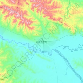
Name: 玛曲县 topographic map, elevation, terrain.
Location: 玛曲县, 尼玛镇, 玛曲县, 甘南藏族自治州, 甘肃省, 中国 (33.83942 101.91007 34.15942 102.23007)
Average elevation: 11,946 ft
Minimum elevation: 11,155 ft
Maximum elevation: 14,721 ft
玛曲县(藏語:རྨ་ཆུ་རྫོང,威利转写:rma chu rdzong,藏语拼音:Maqu Zong)是中华人民共和国甘肃省甘南藏族自治州下属的一个县;位于黄河第一弯曲处。与之接壤的县有:东边碌曲县、四川省若尔盖县,南边四川省阿坝县,西边青海省久治县、甘德县和玛沁县,北边青海省河南蒙古族自治县。岷山横贯,山岭重叠,海拔3600米左右。
Other topographic maps
Click on a map to view its topography, its elevation and its terrain.