
Greenham topographic map
Interactive map
Click on the map to display elevation.
About this map
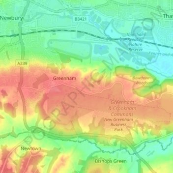
Name: Greenham topographic map, elevation, terrain.
Location: Greenham, West Berkshire, England, United Kingdom (51.36723 -1.33954 51.40171 -1.26925)
Average elevation: 308 ft
Minimum elevation: 210 ft
Maximum elevation: 427 ft
Other topographic maps
Click on a map to view its topography, its elevation and its terrain.
Winterbourne
United Kingdom > England > West Berkshire
Winterbourne, West Berkshire, England, United Kingdom
Average elevation: 394 ft