
Make a donation
Gear up for your next adventure:
As an Amazon Associate, this site earns from qualifying purchases at no extra cost to you.
Villa Kamboja topographic map
Click on the map to display elevation.
Make a donation
Gear up for your next adventure:
As an Amazon Associate, this site earns from qualifying purchases at no extra cost to you.
About this map
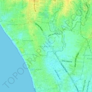
Name: Villa Kamboja topographic map, elevation, terrain.
Average elevation: 26 ft
Minimum elevation: 0 ft
Maximum elevation: 72 ft
Make a donation
Gear up for your next adventure:
As an Amazon Associate, this site earns from qualifying purchases at no extra cost to you.
Other topographic maps
Click on a map to view its topography, its elevation and its terrain.
Ayung River
The Ayung River watershed area has an annual average temperature between 18.4 °C and 26.6 °C, depending on the altitude. The average annual rainfall at the upstream is high, around 1963–3242 mm. Going downstream at an average inclination of 13.13%, the rainfall and the rainy days on the river decrease. In…
Average elevation: 1,457 ft
Make a donation
Gear up for your next adventure:
As an Amazon Associate, this site earns from qualifying purchases at no extra cost to you.
Pecatu
Pecatu is located in South Kuta District of the Badung Regency. It is at the western end of the Bukit Peninsula in south Bali, and has a hilly topography with limestone cliffs isolating small, short beaches that have been privately developed. Nusa Dua, on the opposite side of the peninsula, is flat and is a…
Average elevation: 213 ft