
Thank you for supporting this site ❤️
Make a donation
Make a donation
Gear up for your next adventure:
As an Amazon Associate, this site earns from qualifying purchases at no extra cost to you.
Unterweißenbrunn topographic map
Click on the map to display elevation.
Thank you for supporting this site ❤️
Make a donation
Make a donation
Gear up for your next adventure:
As an Amazon Associate, this site earns from qualifying purchases at no extra cost to you.
About this map
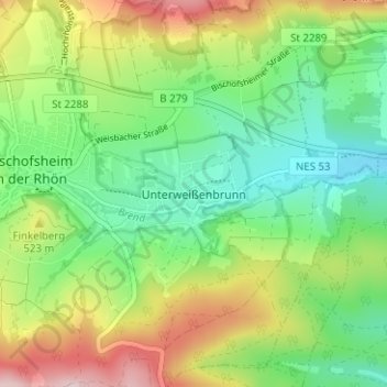
Name: Unterweißenbrunn topographic map, elevation, terrain.
Average elevation: 1,562 ft
Minimum elevation: 1,201 ft
Maximum elevation: 2,175 ft
Thank you for supporting this site ❤️
Make a donation
Make a donation
Gear up for your next adventure:
As an Amazon Associate, this site earns from qualifying purchases at no extra cost to you.
Other topographic maps
Click on a map to view its topography, its elevation and its terrain.
Sinnquellgebiet und Arnsbergsüdhang
Deutschland > Bayern > Landkreis Rhön-Grabfeld > Bischofsheim i.d.Rhön
Average elevation: 2,287 ft
97653
Deutschland > Bayern > Landkreis Rhön-Grabfeld > Bischofsheim i.d.Rhön > Frankenheim
Average elevation: 1,749 ft