Geolocate

Rajsamand topographic map

Click on the map to display elevation.

Rajsamand

Rajsamand is located at 25°04′N 73°53′E / 25.07°N 73.88°E / 25.07; 73.88. It has an average elevation of 547 metres (1794 ft).

Wikipedia (CC-BY-SA 3.0)

About this map

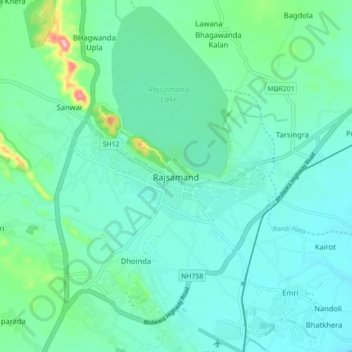
Name: Rajsamand topographic map, elevation, terrain.

Location: Rajsamand, Rajsamand Tehsil, Rajsamand District, Rajasthan, 313326, India (25.01858 73.84808 25.09858 73.92808)

Average elevation: 1,811 ft

Minimum elevation: 1,716 ft

Maximum elevation: 2,251 ft

Gear up for your next adventure:

🦟Ultrasonic Repellers - Create a bug-free zone at your camp or rest stop
🔦Compact Flashlight - Reliable flashlight for emergencies
🪑Portable Camp Table - Compact table for campsite meals
🥾Men's Hiking Boots - Durable, waterproof footwear for rugged terrain and steep inclines
📌Outdoor GPS Map App - Apps and devices for digital topographic navigation

As an Amazon Associate, this site earns from qualifying purchases at no extra cost to you.