
Sachrang topographic map
Interactive map
Click on the map to display elevation.
About this map
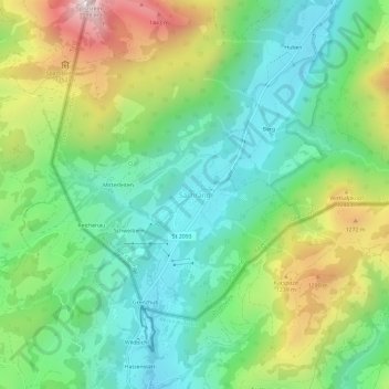
Name: Sachrang topographic map, elevation, terrain.
Average elevation: 3,222 ft
Minimum elevation: 2,280 ft
Maximum elevation: 5,098 ft
Other topographic maps
Click on a map to view its topography, its elevation and its terrain.
Kolbermoor
Germany > Bavaria > Landkreis Rosenheim
Kolbermoor, Landkreis Rosenheim, Bavaria, 83059, Germany
Average elevation: 1,532 ft
Oberaudorf
Germany > Bavaria > Landkreis Rosenheim
Oberaudorf, Landkreis Rosenheim, Bavaria, 83080, Germany
Average elevation: 2,598 ft
Neubeuern
Germany > Bavaria > Landkreis Rosenheim
Neubeuern, Landkreis Rosenheim, Bavaria, 83115, Germany
Average elevation: 1,581 ft
Aschau im Chiemgau
Germany > Bavaria > Landkreis Rosenheim
Aschau im Chiemgau, Landkreis Rosenheim, Bavaria, 83229, Germany
Average elevation: 3,140 ft