
Make a donation
Gear up for your next adventure:
As an Amazon Associate, this site earns from qualifying purchases at no extra cost to you.
Parque Alvorada topographic map
Click on the map to display elevation.
Make a donation
Gear up for your next adventure:
As an Amazon Associate, this site earns from qualifying purchases at no extra cost to you.
About this map
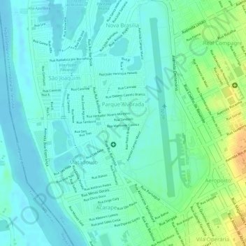
Name: Parque Alvorada topographic map, elevation, terrain.
Average elevation: 210 ft
Minimum elevation: 174 ft
Maximum elevation: 285 ft
Make a donation
Gear up for your next adventure:
As an Amazon Associate, this site earns from qualifying purchases at no extra cost to you.
Other topographic maps
Click on a map to view its topography, its elevation and its terrain.
Santa Maria das Vassouras
Brasil > Piauí > Região Integrada de Desenvolvimento da Grande Teresina > Teresina
Average elevation: 197 ft
Taboca do Pau Ferrado
Brasil > Piauí > Região Integrada de Desenvolvimento da Grande Teresina > Teresina
Average elevation: 427 ft
Formosa
Brasil > Piauí > Região Integrada de Desenvolvimento da Grande Teresina > Teresina
Average elevation: 276 ft
Praça do Boidódromo
Brasil > Piauí > Região Integrada de Desenvolvimento da Grande Teresina > Teresina
Average elevation: 197 ft
Make a donation
Gear up for your next adventure:
As an Amazon Associate, this site earns from qualifying purchases at no extra cost to you.