Geolocate

Gold Run topographic map

Click on the map to display elevation.

About this map

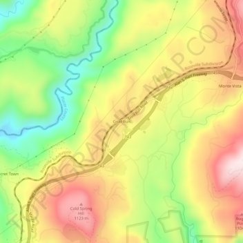
Name: Gold Run topographic map, elevation, terrain.

Location: Gold Run, Placer County, California, 95717, United States (39.16073 -120.87577 39.20073 -120.83577)

Average elevation: 3,051 ft

Minimum elevation: 2,270 ft

Maximum elevation: 3,799 ft

Placer County trails, hiking, mountain biking, running and outdoor activities

Other topographic maps

Click on a map to view its topography, its elevation and its terrain.

Avery's Pond

United States > California > Placer County

Average elevation: 620 ft

Lincoln

United States > California > Placer County

Average elevation: 197 ft

Tahoe Vista

United States > California > Placer County > Kings Beach

Average elevation: 6,644 ft

Lincoln

United States > California > Placer County

Average elevation: 112 ft

Dollar Point

United States > California > Placer County

Average elevation: 6,414 ft

Auburn Ravine

United States > California > Placer County > Auburn

Average elevation: 814 ft

Deer Lake

United States > California > Placer County

Average elevation: 6,624 ft

Gear up for your next adventure:

🏫Relief Map Kits - Hands-on tools for teaching landforms and elevation
📌Outdoor GPS Map App - Apps and devices for digital topographic navigation
🪓Survival Multi‑Tool - Versatile tool for camp and trail tasks
🥇GPS Hiking Watch - Multi‑sport GPS watch with navigation and trail tracking
🧤Tactile Hiking Gloves - Keep hands warm while operating GPS and smartphone screens

As an Amazon Associate, this site earns from qualifying purchases at no extra cost to you.