
Pilsen topographic map
Interactive map
Click on the map to display elevation.
About this map
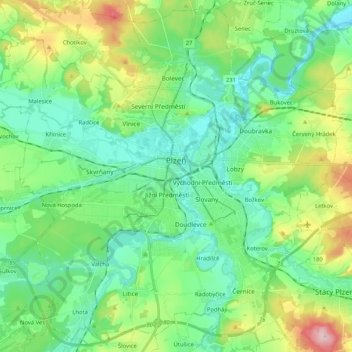
Name: Pilsen topographic map, elevation, terrain.
Location: Pilsen, okres Plzeň-město, Plzeňský kraj, Southwest, Czechia (49.67760 13.26799 49.80576 13.47584)
Average elevation: 1,184 ft
Minimum elevation: 951 ft
Maximum elevation: 1,814 ft
Plzeň has a cool and temperate Oceanic climate (Cfb). Plzeň has low rainfall (604 mm (24 in) year average) evenly spread over the year. Precipitation occurs on average every second day, and the number of days with thunderstorms is 19. It receives on average 1,700 hours of sunshine though winters have longer periods without sunshine. Terrain features and a relatively low altitude (290 to 390 m (950 to 1,280 ft)) give some shelter from strong winds.
Other topographic maps
Click on a map to view its topography, its elevation and its terrain.
Zlín
Czechia > Southwest > Plzeňský kraj > Lišice
Zlín, 18027, Snopoušovy, Lišice, Dolní Lukavice, okres Plzeň-jih, Plzeňský kraj, Southwest, 334 44, Czechia
Average elevation: 1,224 ft
Pancíř
Czechia > Southwest > Plzeňský kraj > Železná Ruda
Pancíř, Železná Ruda, okres Klatovy, Plzeňský kraj, Southwest, Czechia
Average elevation: 3,110 ft
Javor
Czechia > Southwest > Plzeňský kraj
Javor, okres Klatovy, Plzeňský kraj, Southwest, Czechia
Average elevation: 1,611 ft
Chříč
Czechia > Southwest > Plzeňský kraj
Chříč, okres Plzeň-sever, Plzeňský kraj, Southwest, 331 43, Czechia
Average elevation: 1,270 ft
Chodová Planá
Czechia > Southwest > Plzeňský kraj > Chodová Planá
Chodová Planá, okres Tachov, Plzeňský kraj, Southwest, 348 13, Czechia
Average elevation: 1,762 ft
Kožlany
Czechia > Southwest > Plzeňský kraj > Kožlany
Kožlany, okres Plzeň-sever, Plzeňský kraj, Southwest, 33144, Czechia
Average elevation: 1,421 ft
Modrava
Czechia > Southwest > Plzeňský kraj > Modrava
Modrava, okres Klatovy, Plzeňský kraj, Southwest, Czechia
Average elevation: 3,691 ft