
Thank you for supporting this site ❤️
Make a donation
Make a donation
Gear up for your next adventure:
As an Amazon Associate, this site earns from qualifying purchases at no extra cost to you.
Fleur-de-Lys topographic map
Click on the map to display elevation.
Thank you for supporting this site ❤️
Make a donation
Make a donation
Gear up for your next adventure:
As an Amazon Associate, this site earns from qualifying purchases at no extra cost to you.
About this map
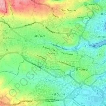
Name: Fleur-de-Lys topographic map, elevation, terrain.
Location: Fleur-de-Lys, Birkirkara, Central Region, BKR 9077, Malta (35.87298 14.45162 35.91298 14.49162)
Average elevation: 154 ft
Minimum elevation: 0 ft
Maximum elevation: 423 ft
Thank you for supporting this site ❤️
Make a donation
Make a donation
Gear up for your next adventure:
As an Amazon Associate, this site earns from qualifying purchases at no extra cost to you.