
Make a donation
Gear up for your next adventure:
As an Amazon Associate, this site earns from qualifying purchases at no extra cost to you.
Buryatia topographic map
Click on the map to display elevation.
Make a donation
Gear up for your next adventure:
As an Amazon Associate, this site earns from qualifying purchases at no extra cost to you.
About this map
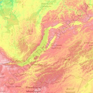
Name: Buryatia topographic map, elevation, terrain.
Location: Buryatia, Far Eastern Federal District, Russia (49.96978 98.62992 57.24988 116.92173)
Average elevation: 3,028 ft
Minimum elevation: 525 ft
Maximum elevation: 10,341 ft
Make a donation
Gear up for your next adventure:
As an Amazon Associate, this site earns from qualifying purchases at no extra cost to you.
Other topographic maps
Click on a map to view its topography, its elevation and its terrain.
Siberia
Russia > Krasnoyarsk Krai > Boguchansky Rayon
Eastern and central Sakha comprises numerous north–south mountain ranges of various ages. These mountains extend up to almost 3,000 metres (9,800 ft), but above a few hundred metres they are almost completely devoid of vegetation. The Verkhoyansk Range was extensively glaciated in the Pleistocene, but the…
Average elevation: 1,135 ft
Make a donation
Gear up for your next adventure:
As an Amazon Associate, this site earns from qualifying purchases at no extra cost to you.
Make a donation
Gear up for your next adventure:
As an Amazon Associate, this site earns from qualifying purchases at no extra cost to you.
Make a donation
Gear up for your next adventure:
As an Amazon Associate, this site earns from qualifying purchases at no extra cost to you.
Makhachkala
Russia > Republic of Dagestan > Makhachkala Urban Okrug > Makhachkala
Average elevation: 305 ft
Make a donation
Gear up for your next adventure:
As an Amazon Associate, this site earns from qualifying purchases at no extra cost to you.
Make a donation
Gear up for your next adventure:
As an Amazon Associate, this site earns from qualifying purchases at no extra cost to you.
Make a donation
Gear up for your next adventure:
As an Amazon Associate, this site earns from qualifying purchases at no extra cost to you.
Yekaterinburg
Russia > Sverdlovsk Oblast > Yekaterinburg Municipality > Yekaterinburg
Average elevation: 899 ft
Make a donation
Gear up for your next adventure:
As an Amazon Associate, this site earns from qualifying purchases at no extra cost to you.
Omsk
Russia > Omsk Oblast > Omsk > Omsk
Omsk is situated in the south of the West Siberian Plain along the banks of the north-flowing Irtysh at its confluence with the Om River. The city has an elevation of 87 meters (285 ft) above mean sea level at its highest point.
Average elevation: 344 ft
Moscow
Moscow is situated on the banks of the Moskva River, which flows for just over 500 km (311 mi) through the East European Plain in central Russia, not far from the natural border of the forest and forest-steppe zone. 49 bridges span the river and its canals within the city's limits. The elevation of Moscow at…
Average elevation: 522 ft
Make a donation
Gear up for your next adventure:
As an Amazon Associate, this site earns from qualifying purchases at no extra cost to you.
Novy Urengoy
Russia > Yamalo-Nenets Autonomous Okrug > городской округ Новый Уренгой > Novy Urengoy
Average elevation: 197 ft
Make a donation
Gear up for your next adventure:
As an Amazon Associate, this site earns from qualifying purchases at no extra cost to you.
Make a donation
Gear up for your next adventure:
As an Amazon Associate, this site earns from qualifying purchases at no extra cost to you.