
Make a donation
Gear up for your next adventure:
As an Amazon Associate, this site earns from qualifying purchases at no extra cost to you.
Maurice River topographic map
Click on the map to display elevation.
Make a donation
Gear up for your next adventure:
As an Amazon Associate, this site earns from qualifying purchases at no extra cost to you.
About this map
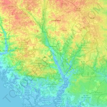
Name: Maurice River topographic map, elevation, terrain.
Location: Maurice River, Cumberland County, New Jersey, United States (39.20839 -75.08374 39.52614 -74.97832)
Average elevation: 52 ft
Minimum elevation: -13 ft
Maximum elevation: 144 ft
Cumberland County trails, hiking, mountain biking, running and outdoor activities
Make a donation
Gear up for your next adventure:
As an Amazon Associate, this site earns from qualifying purchases at no extra cost to you.
Other topographic maps
Click on a map to view its topography, its elevation and its terrain.
Port Elizabeth
United States > New Jersey > Cumberland County > Maurice River Township > Port Elizabeth
Average elevation: 13 ft
Fairfield Township
United States > New Jersey > Cumberland County > Fairfield Township
Average elevation: 49 ft
Commercial Township
United States > New Jersey > Cumberland County > Commercial Township
Average elevation: 16 ft
Make a donation
Gear up for your next adventure:
As an Amazon Associate, this site earns from qualifying purchases at no extra cost to you.