
Make a donation
Gear up for your next adventure:
As an Amazon Associate, this site earns from qualifying purchases at no extra cost to you.
Poitou-Charentes topographic map
Click on the map to display elevation.
Make a donation
Gear up for your next adventure:
As an Amazon Associate, this site earns from qualifying purchases at no extra cost to you.
About this map
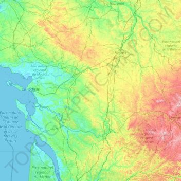
Name: Poitou-Charentes topographic map, elevation, terrain.
Location: Poitou-Charentes, Metropolitan France, France (45.08898 -1.56268 47.17592 1.21319)
Average elevation: 348 ft
Minimum elevation: -7 ft
Maximum elevation: 1,860 ft
Make a donation
Gear up for your next adventure:
As an Amazon Associate, this site earns from qualifying purchases at no extra cost to you.
Other topographic maps
Click on a map to view its topography, its elevation and its terrain.
Grison
France > Pays de la Loire > Loire-Atlantique > Vallons-de-l'Erdre > Saint-Mars-la-Jaille
Average elevation: 161 ft
Make a donation
Gear up for your next adventure:
As an Amazon Associate, this site earns from qualifying purchases at no extra cost to you.