Geolocate

Calawagan topographic map

Click on the map to display elevation.

About this map

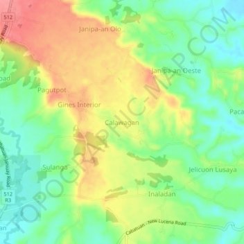
Name: Calawagan topographic map, elevation, terrain.

Location: Calawagan, Iloilo, Western Visayas, 5030, Philippines (10.89422 122.49115 10.93422 122.53115)

Average elevation: 279 ft

Minimum elevation: 157 ft

Maximum elevation: 433 ft

Other topographic maps

Click on a map to view its topography, its elevation and its terrain.

Balasan

Philippines > Iloilo

Average elevation: 138 ft

Banate

Philippines > Iloilo

Average elevation: 112 ft

Miagao

Philippines > Iloilo

Average elevation: 318 ft

Lambunao

Philippines > Iloilo > Lambunao

Average elevation: 417 ft

Anilao

Philippines > Iloilo > Anilao

Average elevation: 171 ft

Bayas Island

Philippines > Iloilo > Estancia > Bayas

Average elevation: 3 ft

Balbagon Island

Philippines > Iloilo > Carles

Average elevation: 0 ft

Leganes

Philippines > Iloilo

Average elevation: 26 ft

Gear up for your next adventure:

Solar GPS Watches - Advanced multisport watches with built-in topographic maps
🔦Compact Flashlight - Reliable flashlight for emergencies
🧤Tactile Hiking Gloves - Keep hands warm while operating GPS and smartphone screens
🔌Solar Panel Charger - Charge gear sustainably outdoors
☀️Outdoor Sunscreen - High protection sunscreen for outdoor activities

As an Amazon Associate, this site earns from qualifying purchases at no extra cost to you.