Geolocate

Minalin topographic map

Click on the map to display elevation.

About this map

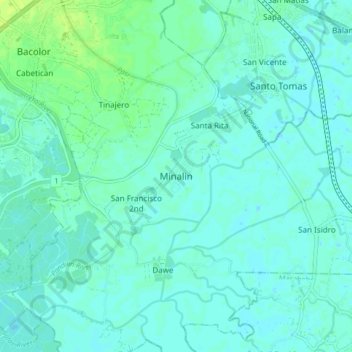
Name: Minalin topographic map, elevation, terrain.

Location: Minalin, Pampanga, Central Luzon, 2019, Philippines (14.92818 120.64492 15.00818 120.72492)

Average elevation: 13 ft

Minimum elevation: -7 ft

Maximum elevation: 39 ft

Other topographic maps

Click on a map to view its topography, its elevation and its terrain.

Candaba

Philippines > Pampanga

Average elevation: 79 ft

Bahay Pare

Philippines > Pampanga > Candaba

Average elevation: 33 ft

Arayat

Philippines > Pampanga

Average elevation: 128 ft

Magalang

Philippines > Pampanga

Average elevation: 187 ft

San Agustin

Philippines > Pampanga > Candaba

Average elevation: 20 ft

Pampanga River

Philippines > Pampanga > Arayat

Average elevation: 279 ft

San Simon

Philippines > Pampanga

Average elevation: 16 ft

Santo Tomas

Philippines > Pampanga > Santo Tomas

Average elevation: 13 ft

San Esteban

Philippines > Pampanga

Average elevation: 10 ft

Lourdes

Philippines > Pampanga > Candaba

Average elevation: 33 ft

Gear up for your next adventure:

🌧️Backpack Rain Cover - Keep gear dry in wet weather
🏥Hiking First Aid Kits - Comprehensive medical kits for remote trail injuries
🪓Survival Multi‑Tool - Versatile tool for camp and trail tasks
🧯Emergency Survival Kit - All‑in‑one survival essentials for the backcountry
👟Men's Trail Runners - Lightweight footwear for fast-paced exploration and light hiking

As an Amazon Associate, this site earns from qualifying purchases at no extra cost to you.