Geolocate

Dulong topographic map

Click on the map to display elevation.

About this map

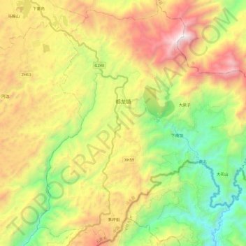
Name: Dulong topographic map, elevation, terrain.

Location: Dulong, Maguan County, Wenshan, Yunnan, China (22.78879 104.44697 22.97779 104.65985)

Average elevation: 4,334 ft

Minimum elevation: 1,355 ft

Maximum elevation: 8,320 ft

Other topographic maps

Click on a map to view its topography, its elevation and its terrain.

Mabai

China > Yunnan > Maguan County > 白马镇

Average elevation: 4,564 ft

Maguan

China > Yunnan > Maguan County

Average elevation: 4,518 ft

Gear up for your next adventure:

🥄Camping Utensil Set - Lightweight utensils for outdoor meals
🧣Hiking Neck Gaiter - Multi‑use neck protection for outdoor weather
🔥Fast-Boil Camping Stoves - Efficient cooking systems for quick trail meals
📻Weather Alert Radios - Stay informed of storm risks while off-the-grid
🧦Merino Wool Socks - Moisture-wicking, blister-preventing socks for long treks

As an Amazon Associate, this site earns from qualifying purchases at no extra cost to you.