
Make a donation
Gear up for your next adventure:
As an Amazon Associate, this site earns from qualifying purchases at no extra cost to you.
Lagoa topographic map
Click on the map to display elevation.
Make a donation
Gear up for your next adventure:
As an Amazon Associate, this site earns from qualifying purchases at no extra cost to you.
About this map
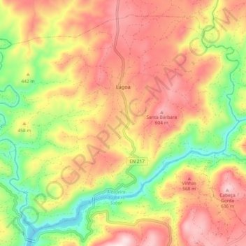
Name: Lagoa topographic map, elevation, terrain.
Location: Lagoa, Macedo de Cavaleiros, Distrito de Bragança, Portugal (41.40489 -6.81712 41.46591 -6.72504)
Average elevation: 1,450 ft
Minimum elevation: 676 ft
Maximum elevation: 2,133 ft
Make a donation
Gear up for your next adventure:
As an Amazon Associate, this site earns from qualifying purchases at no extra cost to you.
Other topographic maps
Click on a map to view its topography, its elevation and its terrain.
Make a donation
Gear up for your next adventure:
As an Amazon Associate, this site earns from qualifying purchases at no extra cost to you.
Fornos de Ledra
Portugal > Distrito de Bragança > Macedo de Cavaleiros > Lamalonga
Average elevation: 1,430 ft
Brinço
Portugal > Distrito de Bragança > Macedo de Cavaleiros > Ala e Vilarinho do Monte
Average elevation: 1,847 ft
Make a donation
Gear up for your next adventure:
As an Amazon Associate, this site earns from qualifying purchases at no extra cost to you.