
Make a donation
Gear up for your next adventure:
As an Amazon Associate, this site earns from qualifying purchases at no extra cost to you.
Tungurahua topographic map
Click on the map to display elevation.
Make a donation
Gear up for your next adventure:
As an Amazon Associate, this site earns from qualifying purchases at no extra cost to you.
Tungurahua
Generally though, Tungurahua experiences temperatures between 14 and 17 degree Celsius in the day-time, with cooler nights. At higher altitudes, conditions are much colder. Despite the area being near the Equator, mountains such as Carihuayrazo and Chimborazo are covered in snow for much of the year.
Make a donation
Gear up for your next adventure:
As an Amazon Associate, this site earns from qualifying purchases at no extra cost to you.
About this map
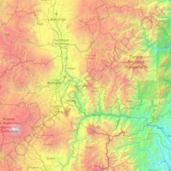
Name: Tungurahua topographic map, elevation, terrain.
Location: Tungurahua, Ecuador (-1.52314 -78.93798 -0.98815 -78.11020)
Average elevation: 10,230 ft
Minimum elevation: 3,015 ft
Maximum elevation: 20,535 ft
Make a donation
Gear up for your next adventure:
As an Amazon Associate, this site earns from qualifying purchases at no extra cost to you.
Other topographic maps
Click on a map to view its topography, its elevation and its terrain.