
Make a donation
Gear up for your next adventure:
As an Amazon Associate, this site earns from qualifying purchases at no extra cost to you.
Khatanga topographic map
Click on the map to display elevation.
Make a donation
Gear up for your next adventure:
As an Amazon Associate, this site earns from qualifying purchases at no extra cost to you.
Khatanga
Khatanga (Russian: Хатанга) is a rural locality (a selo) in Taymyrsky Dolgano-Nenetsky District of Krasnoyarsk Krai, Russia, located on the Khatanga River on the Taymyr Peninsula. It is one of the northernmost inhabited localities in Russia. Its elevation is 30 metres (98 ft) above sea level. As of the 2002 Census, its population was 3,450.[3]
Make a donation
Gear up for your next adventure:
As an Amazon Associate, this site earns from qualifying purchases at no extra cost to you.
About this map
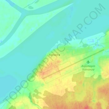
Name: Khatanga topographic map, elevation, terrain.
Average elevation: 36 ft
Minimum elevation: -13 ft
Maximum elevation: 125 ft
Make a donation
Gear up for your next adventure:
As an Amazon Associate, this site earns from qualifying purchases at no extra cost to you.
Other topographic maps
Click on a map to view its topography, its elevation and its terrain.
Schmidt Island
Russia > Krasnoyarsk Krai > Taymyrsky Dolgano-Nenetsky District
Average elevation: 308 ft
сельское поселение Хатанга
Russia > Krasnoyarsk Krai > Taymyrsky Dolgano-Nenetsky District
Average elevation: 515 ft
городское поселение Диксон
Russia > Krasnoyarsk Krai > Taymyrsky Dolgano-Nenetsky District
Average elevation: 148 ft