
Thank you for supporting this site ❤️
Make a donation
Make a donation
Gear up for your next adventure:
As an Amazon Associate, this site earns from qualifying purchases at no extra cost to you.
Chuao topographic map
Click on the map to display elevation.
Thank you for supporting this site ❤️
Make a donation
Make a donation
Gear up for your next adventure:
As an Amazon Associate, this site earns from qualifying purchases at no extra cost to you.
About this map
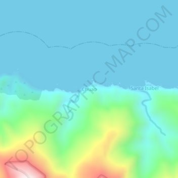
Name: Chuao topographic map, elevation, terrain.
Location: Chuao, Municipio Arismendi, Estado Sucre, Venezuela (10.72193 -62.68121 10.76193 -62.64121)
Average elevation: 443 ft
Minimum elevation: 0 ft
Maximum elevation: 2,444 ft
Thank you for supporting this site ❤️
Make a donation
Make a donation
Gear up for your next adventure:
As an Amazon Associate, this site earns from qualifying purchases at no extra cost to you.
Other topographic maps
Click on a map to view its topography, its elevation and its terrain.
Parque Nacional Península de Paria
Venezuela > Estado Sucre > Municipio Arismendi
Average elevation: 66 ft