Geolocate

Sesma topographic map

Click on the map to display elevation.

About this map

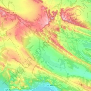
Name: Sesma topographic map, elevation, terrain.

Location: Sesma, Estellerria, Navarre, 31293, Spain (42.41762 -2.16216 42.52869 -2.01008)

Average elevation: 1,371 ft

Minimum elevation: 1,027 ft

Maximum elevation: 1,808 ft

Other topographic maps

Click on a map to view its topography, its elevation and its terrain.

Ecala

Spain > Navarre > Estellerria > Améscoa Baja

Average elevation: 2,372 ft

Gear up for your next adventure:

🌧️Backpack Rain Cover - Keep gear dry in wet weather
🩳Quick‑Dry Hiking Shorts - Comfortable and quick‑dry shorts for summer hiking
🎒Trekking Poles - Sturdy poles for balance and stability on rough terrain
💧Water Purification System - Clean water on the trail with reliable purifiers
🧣Hiking Neck Gaiter - Multi‑use neck protection for outdoor weather

As an Amazon Associate, this site earns from qualifying purchases at no extra cost to you.