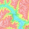
Lhasa topographic map
Click on the map to display elevation.
Lhasa
Lhasa prefecture-level city roughly corresponds to the basin of the Lhasa River, a major tributary of the Yarlung Tsangpo. Exceptions are the north of Damxung County, which crosses the watershed of the Nyenchen Tanglha Mountains and includes part of the Namtso lake, and Nyêmo County, which covers the basin of the Nimu Maqu River, a direct tributary of the Yarlung Tsangpo. The river basin is separated from the Yarlung Tsangpo valley to the south by the Goikarla Rigyu range. The largest tributary of the Lhasa River, the Reting Tsangpo, originates in the Chenthangula Mountains in Nagqu Prefecture at an elevation of about 5,500 metres (18,000 ft), and flows southwest into Lhasa past Reting Monastery.
About this map
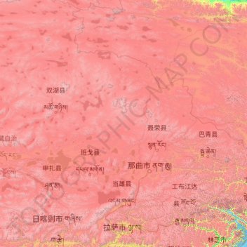
Name: Lhasa topographic map, elevation, terrain.
Location: Lhasa, Xizang, 850000, China (29.24065 89.75281 36.34330 95.16436)
Average elevation: 15,965 ft
Minimum elevation: 9,439 ft
Maximum elevation: 24,495 ft
Other topographic maps
Click on a map to view its topography, its elevation and its terrain.
Mount Kailash
China > Xizang > Purang County > Parga town
Mount Kailash (also Kailasa; Kangrinboqê or Gang Rinpoche; Tibetan: གངས་རིན་པོ་ཆེ; simplified Chinese: 冈仁波齐峰; traditional Chinese: 岡仁波齊峰; Sanskrit: कैलास, IAST: Kailāsa), is a mountain in the Ngari Prefecture, Tibet Autonomous Region of China. It has an…
Average elevation: 18,885 ft

Chumbi Valley
China > Xizang > Yadong County > Xiayadong Township > Rinchengang
The valley is at an altitude of 3,000 m (9,800 ft), and being on the south side of the Himalayas, enjoys a wetter and more temperate climate than most of Tibet. The valley supports some vegetation in the form of the Eastern Himalayan broadleaf forests and transitions to the Eastern Himalayan alpine shrub and…
Average elevation: 10,092 ft