
Make a donation
Gear up for your next adventure:
As an Amazon Associate, this site earns from qualifying purchases at no extra cost to you.
Dale City topographic map
Click on the map to display elevation.
Make a donation
Gear up for your next adventure:
As an Amazon Associate, this site earns from qualifying purchases at no extra cost to you.
About this map
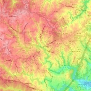
Name: Dale City topographic map, elevation, terrain.
Location: Dale City, Prince William County, Virginia, United States (38.61153 -77.40255 38.68117 -77.28974)
Average elevation: 266 ft
Minimum elevation: 0 ft
Maximum elevation: 410 ft
Prince William County trails, hiking, mountain biking, running and outdoor activities
Make a donation
Gear up for your next adventure:
As an Amazon Associate, this site earns from qualifying purchases at no extra cost to you.
Other topographic maps
Click on a map to view its topography, its elevation and its terrain.
Silver Lake Regional Park
United States > Virginia > Prince William County > Haymarket
Average elevation: 430 ft
Occoquan Bay National Wildlife Refuge
United States > Virginia > Prince William County > Woodbridge
Average elevation: 10 ft
Make a donation
Gear up for your next adventure:
As an Amazon Associate, this site earns from qualifying purchases at no extra cost to you.
Chamberlain Village
United States > Virginia > Prince William County > Quantico > Chamberlain Village
Average elevation: 52 ft
Bull Run Mountain Estates
United States > Virginia > Prince William County > Bull Run Mountain Estates
Average elevation: 646 ft