
Make a donation
Gear up for your next adventure:
As an Amazon Associate, this site earns from qualifying purchases at no extra cost to you.
Paxton topographic map
Click on the map to display elevation.
Make a donation
Gear up for your next adventure:
As an Amazon Associate, this site earns from qualifying purchases at no extra cost to you.
Paxton
Due to Paxton having the highest elevation points in the area, the Illinois Central Railroad dug out ground so that the railroad could move at the same elevation, but underneath the city of Paxton. When the railroad was cut (around the 1920s), several bridges were built across the railroad to connect the east and west sides of Paxton. Presently, there are three vehicular bridges, which are located at Holmes Street, Pells Street and Patton Street, and a pedestrian bridge at Orleans Street.
Make a donation
Gear up for your next adventure:
As an Amazon Associate, this site earns from qualifying purchases at no extra cost to you.
About this map
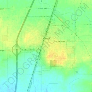
Name: Paxton topographic map, elevation, terrain.
Location: Paxton, Ford County, Illinois, 60957, United States (40.44400 -88.13188 40.46999 -88.07879)
Average elevation: 784 ft
Minimum elevation: 741 ft
Maximum elevation: 827 ft
Ford County trails, hiking, mountain biking, running and outdoor activities
Make a donation
Gear up for your next adventure:
As an Amazon Associate, this site earns from qualifying purchases at no extra cost to you.