
Make a donation
Gear up for your next adventure:
As an Amazon Associate, this site earns from qualifying purchases at no extra cost to you.
Reisach topographic map
Click on the map to display elevation.
Make a donation
Gear up for your next adventure:
As an Amazon Associate, this site earns from qualifying purchases at no extra cost to you.
Reisach
Birklmühle | Bodendorf | Bronn | Buchau | Büchenbach | Großkrausmühle | Haidmühle | Hainbronn | Hammerbühl | Hedelmühle | Heroldsreuth | Herrenmühle | Hollenberg | Horlach | Hufeisen-Waldhaus | Kaltenthal | Kleinkrausmühle | Körbeldorf | Kosbrunn | Kotzenhammer | Langenreuth | Lehm | Leups | Leupsermühle | Lobensteig | Lüglas | Nemschenreuth | Neudorf | Neuhof | Oberhauenstein | Pegnitz (Kernbereich) | Penzenreuth | Pertenhof | Reisach | Rosenhof | Scharthammer | Stein | Stemmenreuth | Trockau | Troschenreuth | Unterhauenstein | Vestenmühle | Weidelwangermühle | Weidmannshöhe | Willenberg | Willenreuth | Wolfslohe | Ziegelhütte | Zips
Make a donation
Gear up for your next adventure:
As an Amazon Associate, this site earns from qualifying purchases at no extra cost to you.
About this map
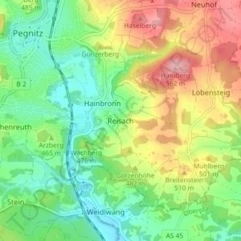
Name: Reisach topographic map, elevation, terrain.
Average elevation: 1,529 ft
Minimum elevation: 1,322 ft
Maximum elevation: 1,850 ft
Make a donation
Gear up for your next adventure:
As an Amazon Associate, this site earns from qualifying purchases at no extra cost to you.