
Thank you for supporting this site ❤️
Make a donation
Make a donation
Gear up for your next adventure:
As an Amazon Associate, this site earns from qualifying purchases at no extra cost to you.
Huayno topographic map
Click on the map to display elevation.
Thank you for supporting this site ❤️
Make a donation
Make a donation
Gear up for your next adventure:
As an Amazon Associate, this site earns from qualifying purchases at no extra cost to you.
About this map
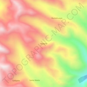
Name: Huayno topographic map, elevation, terrain.
Location: Huayno, Sivia, Huanta, Ayacucho, Perú (-12.63715 -74.08633 -12.59715 -74.04633)
Average elevation: 12,257 ft
Minimum elevation: 10,305 ft
Maximum elevation: 13,543 ft
Thank you for supporting this site ❤️
Make a donation
Make a donation
Gear up for your next adventure:
As an Amazon Associate, this site earns from qualifying purchases at no extra cost to you.