Geolocate

Telford topographic map

Click on the map to display elevation.

About this map

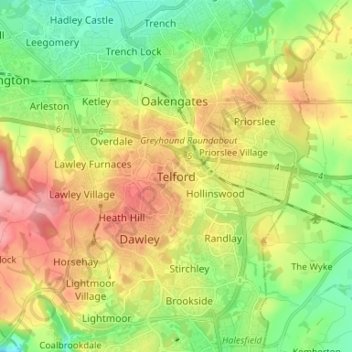
Name: Telford topographic map, elevation, terrain.

Location: Telford, Telford and Wrekin, England, TF3 4HB, United Kingdom (52.63805 -2.49142 52.71805 -2.41142)

Average elevation: 446 ft

Minimum elevation: 184 ft

Maximum elevation: 817 ft

Other topographic maps

Click on a map to view its topography, its elevation and its terrain.

Madeley

United Kingdom > England > Telford and Wrekin

Average elevation: 381 ft

Wrockwardine

United Kingdom > England > Telford and Wrekin

Average elevation: 308 ft

Edgmond

United Kingdom > England > Telford and Wrekin > Edgmond

Average elevation: 240 ft

Wellington

United Kingdom > England > Telford and Wrekin

Average elevation: 305 ft

Ketley

United Kingdom > England > Telford and Wrekin > Telford

Average elevation: 417 ft

Play Park

United Kingdom > England > Telford and Wrekin > Dawley

Average elevation: 577 ft

Kynnersley

United Kingdom > England > Telford and Wrekin

Average elevation: 187 ft

Madeley

United Kingdom > England > Telford and Wrekin

Average elevation: 381 ft

Wrockwardine

United Kingdom > England > Telford and Wrekin

Average elevation: 308 ft

Edgmond

United Kingdom > England > Telford and Wrekin > Edgmond

Average elevation: 240 ft

Madeley

United Kingdom > England > Telford and Wrekin

Average elevation: 381 ft

Madeley

United Kingdom > England > Telford and Wrekin

Average elevation: 381 ft

Gear up for your next adventure:

🧣Hiking Neck Gaiter - Multi‑use neck protection for outdoor weather
🔥Fast-Boil Camping Stoves - Efficient cooking systems for quick trail meals
GPS Sports Watch - GPS watch for running, hiking and training
📱Solar Portable Charger - Solar power bank for charging devices off‑grid
🛡️Bear Spray Outdoor - Protection in bear country hikes

As an Amazon Associate, this site earns from qualifying purchases at no extra cost to you.