
Make a donation
Gear up for your next adventure:
As an Amazon Associate, this site earns from qualifying purchases at no extra cost to you.
Kaduru topographic map
Click on the map to display elevation.
Make a donation
Gear up for your next adventure:
As an Amazon Associate, this site earns from qualifying purchases at no extra cost to you.
Kaduru
Kadur is located in the eastern part of Chikmagalur district, which has a semi-arid climate. Its elevation is around 760 metres above the mean sea level. It has a dry climate with annual rainfall less than 750 millimetres (30 in).
Make a donation
Gear up for your next adventure:
As an Amazon Associate, this site earns from qualifying purchases at no extra cost to you.
About this map
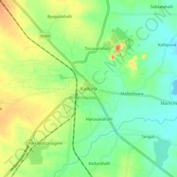
Name: Kaduru topographic map, elevation, terrain.
Location: Kaduru, Kaduru taluk, Chikkamagaluru, Karnataka, 577548, India (13.51275 75.97424 13.59275 76.05424)
Average elevation: 2,510 ft
Minimum elevation: 2,405 ft
Maximum elevation: 2,697 ft
Make a donation
Gear up for your next adventure:
As an Amazon Associate, this site earns from qualifying purchases at no extra cost to you.