
Casar topographic map
Click on the map to display elevation.
About this map
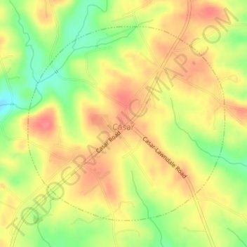
Name: Casar topographic map, elevation, terrain.
Location: Casar, Cleveland County, North Carolina, United States (35.50208 -81.63016 35.52331 -81.60366)
Average elevation: 1,083 ft
Minimum elevation: 955 ft
Maximum elevation: 1,168 ft
Cleveland County trails, hiking, mountain biking, running and outdoor activities
Other topographic maps
Click on a map to view its topography, its elevation and its terrain.
Osborne Apartments
United States > North Carolina > Cleveland County > Shelby
Average elevation: 840 ft