Geolocate

Burke topographic map

Click on the map to display elevation.

About this map

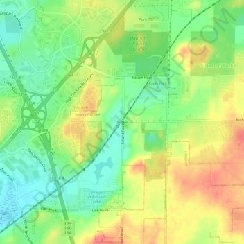
Name: Burke topographic map, elevation, terrain.

Location: Burke, Madison, Dane County, Wisconsin, 53718, United States (43.11583 -89.29623 43.15583 -89.25623)

Average elevation: 958 ft

Minimum elevation: 853 ft

Maximum elevation: 1,079 ft

Dane County trails, hiking, mountain biking, running and outdoor activities

Other topographic maps

Click on a map to view its topography, its elevation and its terrain.

Capitol Square

United States > Wisconsin > Dane County > Madison

Average elevation: 860 ft

Monona Bay

United States > Wisconsin > Dane County > Madison

Average elevation: 873 ft

Gear up for your next adventure:

🪶Camping Sleeping Pad - Comfortable sleeping pad for backpacking
🕶️GPS Smartphone Mount - Secure mount for phone navigation
🔥Fast-Boil Camping Stoves - Efficient cooking systems for quick trail meals
📷Action Cameras - Rugged cameras to document your journeys across rugged terrain
🩳Quick‑Dry Hiking Shorts - Comfortable and quick‑dry shorts for summer hiking

As an Amazon Associate, this site earns from qualifying purchases at no extra cost to you.